→ Part 2 - the journey from Everest Base Camp
→ The journey to Everest Base Camp
It has taken quite a few days for me to be able to write about the hike to Base Camp. I think there were a combination of reasons for that. Mainly it was sheer exhaustion. At altitude you sleep so poorly, then your body works so hard to do every single thing - even tying a shoelace takes your breath away! The other thing I found was that it was difficult to think that clearly at altitude, so sitting down to blog was really not compelling. And if those weren’t reason enough, there was the matter of cost too.... it’s difficult to be creative and spontaneous when the cost to use the internet in some of the higher villages was more than $1 per minute. So, enough of excuses, now I’m at a hotel with free internet in Kathmandu and feel compelled to share a little of what Everest Base Camp and the trek is like.
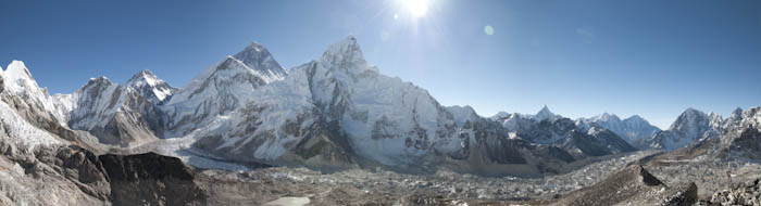
It’s impossible to separate Base Camp from the trek. If you were to view Base Camp in isolation, you could almost be disappointed - when we arrived, the climbing season was over, so all that stood there was a big rock with Everest Base Camp graffitied on it (probably by Australians!) and prayer flags flapping in the breeze haphazardly. Down on the valley floor below us was the enormous Khumbu glacier with white peaks all over it like the top of a pavlova. And looking up towards where Mt Everest was hidden behind Nuptse and Lhotse we could see the Khumbu icefall tumbling down to the glacier. To give an idea of the scale of the icefall, in a story about climbing Mt Everest that I’ve been reading, the author Beck Weathers describes his experience of attempting the icefall like being an ant at the bottom of the icebox. And that’s only the very beginning of an Everest ascent!
Describing what you see at Base Camp misses the main part of the story of the Everest Base Camp trek in my experience. From the beginning we realised that the entire journey is the destination. We spent a fortnight on the trail - we flew into Lukla on Thursday 4 November all clean, bright eyed and full of anticipation; by the time we stumbled back into Lukla on Thursday 18 November we looked and felt quite wild and utterly exhausted. We hadn’t showered for 8 days, our few clothes hadn’t been washed for a fortnight and we were looking a little skinny and dehydrated - not surprising given that we’d just completed 104km of trekking, gaining and losing almost 7000m of altitude over that time.
The hiking begins in forested hill country and passes through lots of little villages where the people live very simple lives, tending their small crops and operating small tea shops or lodges to feed and accommodate the thousands of trekkers who pass by each spring and autumn. When the sun is out, it’s warm, but in these villages once the sun has set, life is lived inside in darkened kitchens warmed by the fire. We were lucky enough to stay in a couple of smaller lodges where you are almost part of the family for the evening. I loved having that chance to watch them busy around the stove making up the dishes fresh as we ordered them.
On some days the hiking is really hard and long - the steep uphills into Namche Bazaar and Tengboche come instantly to mind. They were gruelling days with endless ‘switchbacks’, where the trail just turns back and forward upon itself going higher and higher without respite. But as difficult as we found those sections, we could never moan about it, because we were constantly passing or being passed by porters, who carried hugely laden baskets on their backs supported by a strap across their heads. My backpack weighed about 14kg, Damien’s about 20kg. We found those weights hard to bear on some sections. The porters carry loads of up to 140kg. And they are not big people, they are short and typically small framed. It was humbling to see how hard they have to labour to make their small wages. And it was somewhat confronting to see that most of the goods they carted up and down those mountains were the ‘essential’ supplies for western travellers - beer, softdrinks, cigarettes, tinned juices, bottled water.
There is no road access along the base camp trail. Every building material is walked in either on the back of porters, or on the back of cattle trains. So it is startling to rise up and up, into the high mountain territory and come across a town like Namche Bazaar. For hundreds of years this village has been a major trading point between Tibet and Nepal. When we returned to Namche on our way back we were happy to witness that this is still the case. In the potato field behind our lodge, Tibetan traders who had crossed the high pass between Mt Everest and PumoRi, had set up a market selling clothes and blankets from China to the Nepalese porters. The Tibetans had very basic tarpaulin tents for shelter, but our lodge owner told us they don’t sleep in them, they worry that their big bag loads of goods will be stolen overnight, so they sleep on their piles of merchandise. For us this was an insight into lives of such deprivation and hardship that I found difficult to comprehend.
From Namche Bazaar onwards, acclimitising to the altitude was the rule governing how far we could hike in a day. So there were a few days where we just had a 2 to 3 hour hike then spent the afternoons lazing (recovering) about the lodges. This sounds a whole lot more salubrious than it was. In all of the villages, there is a kind of rule that the warming stove in the dining room doesn’t get lit until 4 or 4.30pm. We were absolutely blessed with fantastic weather every single morning of our hike - clear blue skies and cloudless mornings. After the sun rose above the high peaks around 9am and we started hiking, we were really quite warm while we hiked. Once we stopped walking however we cooled down very quickly. And as I wrote from Pheriche, the clouds would follow us up the valley as we hiked and by early afternoon there was typically full cloud cover which took away all of the sun’s delicious heat. So on days where we only had a short hike, we typically would pass the afternoon just lying in our sleeping bags, reading books and waiting until the dining room heated up.
The landscape changed day by day, growing more extreme the higher we ascended. Tall fir trees along the lower parts of the valley gave way to smaller gnarly rhododendrons and junipers with spanish moss draped from their limbs. As we rose up to Dukla and towards Lobuche, plant life disappeared altogether, replaced by harsh rocky slopes. By Gorak Shep, the final village before Base Camp it was just a completely inhuman environment. I thought it looked more lunar than earthly.
So by the time we trudged our way into Everest Base Camp, our heads were already filled with the whole experience of getting there, surviving the elements and achieving a goal that we had both held in our sights for so long. These are just a few of the impressions that come to mind of the journey to Base Camp. We hiked up Kala Pattar the next morning to get a view of the mountain we had come to see (you don’t see Everest from Base Camp). It was so gruelling that we couldn’t really celebrate it at the time. There was no energy for high fiving or whooping and back slapping. I think we shook hands and took photos. That was effort enough.
The journey back from EBC as we now know it was also eventful. But enough for now. I’m in Kathmandu and it’s breakfast time. They make a wonderful coffee here..... I’ll write about the homeward journey another time.
→ Pheriche on a cold and cloudy Wednesday
The big dining room at the Himalayan Lodge is filling with tired walkers coming up from Tengboche or down from Everest Base Camp and Kala Pattar.
Everyone is seeking warmth. After a glorious blue morning, Pheriche has turned bitterly cold. A dense layer of cloud has blown up into this desolate valley. Now there's not a soul to be seen out in the cobbled laneways outside. Everyone has retreated into the warm dining rooms of the dozen or so lodges in the village.
Two mountain horses brace themselves against the wind as they scrounge for feed around the courtyard of our lodge. It's very slim pickings, nothing but dirt and rocks.
Pheriche sits on the side of a valley carved out by glaciers long ago. It is inhospitable territory here - the altitude at 4240m has us well above the vegetation zone. There are no trees or shrubs. Not even grasses. Just sparse dry ground cover. I feel sorry for the mountain horses, cows and hairy yaks which have free range up here. There's so little fodder for them and they have no shelter from that vicious wind.
Life in the lodges is very convivial. When the weather is foul there is nothing to do but laze around in the lounge warmed by the stove that's fuelled by dried yak dung.
We read books, write journals, play cards and trade trekking stories with other hikers over steaming lemon tea. We've teamed up with a couple of Canadians and another couple of Australians. It's great meeting up with them here and there.
There has been plenty of drama here in the mountains and it gets gossiped about in the lodges - about the helicopter that crashed the other day at Ama Dablam, just a few kilometres from here; and yesterday a Polish hiker very ill with mountain sickness was taken down to Namche Bazaar on horseback - his expedition had a journalist with them and so it was all over the Polish newspapers or so the gossip goes...
We feel like we're right amongst the action here surrounded by 5000+ metre peaks in all directions. Tomorrow we set off for Dughla as we work our way closer to Everest Base Camp.
→ Our daily walk - October 13
With less than 3 weeks before we depart we've made our physical preparation for Base Camp part of our daily life. We are incredibly fortunate to have the best hiking in the greater Launceston area literally on our doorstep. Every day we walk out our door and down to Duck Reach Station at Cataract Gorge and home again. We've decided that this 4 km return trip which rises and falls more than 120m according to Damien's GPS is the minimum hike we'll do each day before departing.
On days like today where we don't have any work to attend to, we're doing a long hike which takes us over to Trevallyn, crossing the bridge at Duck Reach, passing by the Daffodil Walk at the back of the Basin, and continuing by road down to Cafe Culture, where we stop for breakfast and to read the papers. Who said a training hike had to be all work and no pleasure? Weighed down by the best Eggs Benedict around, we then walk back home usually via the road and Kings Bridge because it's a shorter route back. The hill at the end is a killer though, almost enough to make us rue that second coffee.
This long walk is 10 km and the only flat parts of it are where we cross the bridges. So it's the ideal training ground in terms of distance and terrain. Of course it's about 3000m short on altitude, but you can't have everything can you...
→ Where have the months gone? Oct 6
I'm appalled to see it has been 3 months since I've done any Basecamp Dreaming. I'd like to say that we've been too busy with our preparations to write about it. Unfortunately that's not the case.
The weeks have marched by us seemingly at double time. In early August we went up to the Sunshine Coast to thaw out for a week. That was wonderful and we took the opportunity to stop off in Melbourne to catch an AFL match at the G.
We returned to chilly Launceston and within a day or two I came down with a cold which Damien and then the girls caught too. Between the lot of us we were laid low for a full month. The last thing we thought about during our confinement was preparations for Base Camp. We could barely get ourselves out of bed let alone out into the chilly great outdoors.
Then along came the September school holidays followed by the never-ending 40th birthday celebrations - by which time our health had improved.
One thing we realised is that the best preparation we can have is to arrive in Nepal in good health. It's near impossible to undertake a serious hike when you can't breathe. And as the air gets thinner, it gets much harder. So as great as it would be to be in peak physical form when we arrive over there, we'll happily settle for arriving in good health. That's our focus for now. And we're fitting in short hikes around Cataract Gorge a couple of times a week while we're recovering. We're so lucky to have a beautiful (and challenging) hiking track right outside our front door.
We have less than 4 weeks to go before we depart - we'll be on the plane before we know it. I hope that when we're over there and life is lived at a walking pace, that everything slows down and we can make this experience of a lifetime last.
→ July 4-7 at Cradle Mountain
Sat 4/7 Dove Lake to Waterfall Valley Hut
Sun5/7 Waterfall Valley Hut to Lake Will turnoff, to Scott Kilvert Hut
Mon 6/7 Scott Kilvert Hut across Face Track of Cradle Mountain to Dove Lake
We were hoping to test our gear out for its snow capability so we headed off for a couple of days of winter hiking at Cradle Mountain.
Departing Launceston, we noted the snow line visible on the heights Ben Lomond. We thought about changing our plans and hiking up there, but the lure of Cradle Mountain was too strong.
We loaded up our backpacks and set off from Dove Lake heading up the steep Marion's Lookout track. We were able to manage that ascent quite easily despite the weight we were carrying. Damien has mapped each day of our Nepal trek and has identified that the steepest part of that trip (the day walking up to Namche Bazaar) has a similar gradient (albeit at higher altitude) to the gradient at Marion's Lookout. It's helpful being able to relate aspects of the Base Camp trek to other hikes we've done. It starts to give us some idea of the rises and falls of each day - the x factor of course will be the effect of walking at altitude.
It was as spectacular as ever up on the plateau. We feel so privileged to be able to spend time in this pristine Tasmanian wilderness. The undulations of valleys and mountain ranges stretch out as far as the eye can see in every direction. Everyone thinks of Tasmania as a small island (you can drive it from top to bottom in three hours) and yet that vast expanse of wilderness surrounding us up there could take a lifetime to explore.
We encountered a little snow and ice as we crossed the Cirque, not much, but enough for us to discover that we're not very practiced at walking across sheet ice (and not that keen on it either). Some other hikers we spoke with about it said that walking poles are a great help on ice. So we're going to try some out on Ben Lomond in the next couple of weeks to see for ourselves. We're also looking into using lightweight crampons attached to our boots to really be safe on the ice. It's all a learning exercise that we're happy to be undertaking here at home before we get over to Nepal.
The temperatures ranged between 6 degrees and 0 during our three days and we were both totally comfortable in our hiking gear throughout the three days. I find the handiest things are gloves and a fleece headband which go on and off as I cool down and heat up. We need to get some down sleeping bags so we don't get cold at night. The huts have some heating, but not enough to get through the night.
We met some really great people at Scott Kilvert Hut - a bunch of uni students out of Hobart. After dinner we all sat around the blazing coal stove and talked for hours, sharing our chocolate as we rested our tired muscles. One of the funny aspects of hut hiking is that you get to learn quite a lot about the people you are sharing the hut with in no time at all. It's communal living - there are no private bedrooms. So you know what they wear to bed, when they are going to the toilet, what they read in bed, whether they snore or make other noises in the dark.... all of these intimacies you get to share within just a couple of hours of meeting them. It's quite the departure from the typically slow and steady unfolding into friendship that takes place in polite society.
The area around Scott Kilvert Hut beside Lake Rodway was a joy to discover. The sun came out on our final morning and there wasn't a breath of wind. So we found a spot beside the lake where we could sit and soak up the rays and the view for a while.
Our hike back to the car took us past Flynn's Tarn and the rapids which run from it into Lake Rodway. We climbed up on to the Face Track and traversed across Cradle Mountain with its craggy pinnacles rising.
There was such a great variety to the terrain, the views and the hiking challenges presented on that three day circuit. It has become a new favourite - one that the girls will really enjoy. We plan to take them on that journey very soon. It's a really accessible hike we hope we can share with our friends and family.
→ June 27 - Different people, different approaches
It seems Sunday is turning out to be Basecamp Dreaming day. I just re-read the previous post from a fortnight ago and am really happy to see that we're making good progress.
We've moved straight on to the action phase: creating task lists, building up our itinerary, testing out our gear and even starting our physical training in preparation for Base Camp.
I'm noticing how differently Damien and I define 'preparation'.
I am the personification of the ill-prepared, fly by the seat of your pants traveller. The most I usually manage is a browse through a glossy destination brochure or perhaps a quick flick through an out of date Lonely Planet guide book. Damien on the other hand is the data-driven, minutely researched, detailed itinerary type of traveller. It's such a relief.
The other day I confessed to him that in 1999 I arrived at Uhuru Peak on top of Mt Kilimanjaro in Africa wearing a pair of corduroy jeans and a wax jacket I had borrowed from Tania. My hiking partner at the time, Adam, had asked me where my hiking boots were (I was wearing a kind of cross trainer) and did I have gators? I had to ask him what gators were. I remember being surprised that we were hiking through knee-deep snow and wondered how it was that I hadn't found out before reaching 5895m above sea level.
There is absolutely no chance of that happening this time. Before we even touch down in Nepal Damien will know every inch of the 175km or so of terrain which will be our constant companion for 16 days or so. Using Google Earth he is entering the GPS co-ordinates of each day's progress so that he can pinpoint on a 3D rendering where we will (should??) be at pretty-much any moment on any day of our trek; the altitude we will be at, where our nearest water source is, the quality of the nearest tea house and probably how many steps we are from the nearest loo!
Already he has input the data for the 10 days which take us from Lukla to Everest Base Camp - he presses the go button and you are taken on a 3D journey across a terrain map which flies across from Monju to Namche Bazaar on to Tengboche, across to Lobuche and finally Gorak Shep before the day you trek in to Base Camp. It is so amazing to be able to mouse-click on a terrain map and turn your angle this way and that to see what we'll be seeing with our own eyes. He had better be careful, because if the image gets any more detailed then there will really be no need for us to go ourselves, we could just do the virtual Base Camp trek and see all the sights without even getting our toes cold.
Speaking of cold toes - we decided our Tassie winter provided the perfect conditions to test out our gear for its capability in extreme weather. Kath's husband Andy is in training for a Kilimanjaro trek in August, so we teamed up to do a hike on Mount Roland on Friday of this week. The weather forecast was foul - rain and gale force winds - couldn't ask for better gear testing conditions.
Damien and I headed out to Sheffield the day prior and did Mt Claude in showery, cloudy and cold conditions. What can I say about it? It was a trudge up a steep access road to a communications tower then a walk across a blustery saddle with zero visibility. The most striking feature was a kidney on the path - a water-logged and pale kidney. We didn't discover the creature from which it had come.
At the summit of Mt Claude there is a chock-stone between two very tall rocks. We had read on the Bushwalk forum on the web about various ways of getting up to the top of the rocks which circumvented the need to cross over the apparently daunting chock-stone.
First we went hunting for the cave with the blue rope in it which seemed the most promising way up. But no luck. Oh well, thought I, at least we made an effort.... never-mind... back down to a warm and dry cafe we go.
But no, Damien suggested we try around the other side of the mountain. Jack the dog and I followed. The low lying alpine heath gave way to chest high scrub as we rounded the big rock, and then became a forest of dense prickly stuff that was well over my head. And we were pushing through it, like early explorers in the Amazonian jungle. I had no idea where we were going and we stayed in range by calling out to each other. "I must be stupid" I thought to myself more than once. By the sounds Jack made as he contemplated jumping off slippery conglomerate boulders into unknown depths of scrub below he was thinking the same thing.
Finally, thankfully, we conceded defeat to the gale-force wind, the zero visibility, the slipperyness of the rock and we turned for home. I very nearly skipped the whole way back to the car. There's nothing quite like the promise of warmth and dryness to put a spring in your step.
We ended up in Sheffield, cosy in the drab surrounds of the Sheffield Pub. Spend a day out in conditions like that and even the drabbest pub is positively luxurious. A couple of beers, plates laden with stodgy pub food, some reasonable red wine and we were fortified for our next day's hiking.
Friday made Thursday's weather seem almost hospitable. It was a deluge. I felt we owed it to Andy to let him know what he was in for before he left Launceston. I texted him the news that it was raining hard. He came back with this "Chance of precipitation 100%; Motivation 80%. I'll be there, just a bit later".
So we three headed up Mount Roland grateful at least that the temperature was a reasonably warm 12 degrees even if it was bucketing down on us. Mount Roland is a much nicer walk than Mt Claude - no communications towers to remind us of civilisation. No kidneys on the path to remind us of deadly creatures which may be lurking in the forest either.
Up and up we walked, passing pleasantly named landmarks - Charlie's waterhole with its charming plunging waterfall, and Misty Rise which was well and truly misty. The streams channelling underneath the path became tannin-stained rivulets spilling over the path which we rock-hopped through. We were already drenched but we were doing our best to keep our boots dry on the inside for as long as possible.
Soon enough though, we found ourselves fording rapids roaring with a deluge of water plunging downhill. That was the end of dry boots - in fact dry anything - for the rest of the hike. From that point on we became one with the water. It came from the sky. It filled the walking track - we spent the next couple of hours ankle deep in it.
We decided to bypass the Mt Roland summit track - there were no views to be had on this day - in favour of a shorter route back across Mt VanDyke. Andy called it the path less travelled. And that became pretty apparent. We were back to pushing our way through head high scrub again. Only this time we were doing it in a slippery flood. My feet were frozen so I had to avoid the water whenever possible, which meant walking across the heath scrub. I felt bad about crushing the bushes, but figured it was more important to keep my toes intact. In parts the descent was less like hiking on a walking track and more like being part of a human waterfall, just going with the flow.
I hit the ground maybe 6 times on the descent - every surface was slippery, especially the rocks, tree roots and the mud (which is basically everything). Damien had to fish me out of some bush that swallowed me whole. He grabbed the back of my jacket and returned me to an upright position. He reckons I need to come with a handle attached to my back.
We were waiting for a turn off back down to the O'Neill Reserve - if we missed that we'd be hiking across to Mt Claude again. None of us was interested in that, so we kept a keen look out for the fork in the path. We managed to find it and returned to the lower terrain of the track, noting how benign everything appeared down below. At the base everything seems so harmless - but in the four and a half hours it had taken us to go up, over and down the mountain we had become well versed in just how different the conditions are higher up.
It's all a good lesson for us - for me at least - and that's the whole idea of doing these training hikes in all conditions, so we know the sorts of things we need to prepare for when we are over in the land of extremes.
One thing we now know for sure - there's nothing quite like a 700 loft down jacket to sink into when you've finished your day's hike...
In coming weeks we plan to do the hike from Dove Lake along the Overland Track to Waterfall Valley then down to Scott Kilvert Hut returning to Dove Lake. Who knows... next time we may have the challenge of hiking in snow!
→ Sunday June 13 - Only 4 months to go!
I had entitled this 5 months to go, but when I looked at the calendar I realised that it's now less than 4 months away. Eeek! How exciting.
Already the Base Camp trip has entered into my everyday thinking. Yesterday, Saturday morning, I walked from home down to the Gorge and across the back of the Cliff Grounds right down to Cafe Culture at Trevallyn. Damien met me there for a late breakfast and then I walked back home again via the zigzag track.
It was the gentle beginnings of the training to increase my fitness before we go. Damien thinks that we are sufficiently practiced at walking for long periods to be physically capable of doing the Base Camp trek, but that the more improved our fitness is before we go, the more comfortable we'll be while we're on the trek.
Given that we have 16 days of hiking at altitude, I figure that anything we can do now to make those days more comfortable is a worthwhile effort.
Even though it's four months off, we're already starting to think about our kit. It was the down jackets that got us started. Many of the Base Camp blogs refer to down jackets as being a must have. We rationalised to ourselves the other day that if we're going to get down jackets for our October trip, there's no sense waiting until then to get them given that we have a long cold winter ahead of us here.
We started our down jacket research at Paddy Pallins one afternoon. A slow browse through an outdoors shop has become our favourite way of treating ourselves after we get our jobs done. We didn't like the short length of Paddy's North Face jackets, nor the bright blue colour of the Berghaus ones. A couple of days later we checked out Mountain Designs range. They were better but we weren't wowed by them. And given that they cost $399 we figure we should be able to expect a wow.
Kathmandu is located just a street behind Mountain Designs, so while we were on a roll we figured it made sense to complete our research then and there. The down jackets were right at the front of the store and they had a good range. Both Damo and I found the style we liked. They looked good. There was a spring in our step. I was weighing up between a 700 loft goosedown one and another of unknown loft, and I asked the sales assistant the price of the untagged mystery loft jacket. 'You want to know the sale price right?' she asked me tantalisingly. Sale - what sale? This was news to Damien and me.
It turns out that next Wednesday Kathmandu's down jackets are half price. That's right - down from $500 to $250! Not only did we locate the jackets we liked the best; the jackets we had both silently decided we'd purchase at the appropriate time, but we were now virtually being given $250 back in each of our pockets. We've put the Kathmandu sale in our electronic diaries. We wouldn't miss it for the world. And we've already planned to spend Damien's $250 unspent down jacket dollars on a new pair of hiking pants for him. I'm too excited to even think about what I'll spend my unspent dollars on yet.
We're putting together a packing list and then we plan to take a look at what we already have so we can work out the things that we need to acquire. This way we can spread out the spending over a few months and also take advantage of any sales that come up. So today I've pulled out my gear bag and started sorting through it. When I do something like that, with Base Camp in mind, I start getting all excited about the trip. Wondering what it will be like. Imagining the terrain, the culture, the people we'll encounter along the way. It's really quite intoxicating. I am almost high just at the thought of it.
→ Sunday June 6 - Everest Base Camp in our sights
It seems that both Damien and I have spent a long time of dreaming about someday trekking in the Himalayas. Well guess what.... we've decided that this is the year we'll make it happen. We're making plans to go during the northern Autumn (September-November) which is the best trekking time.
Why Everest Base Camp?
D: From my earliest thoughts of travel, Mt Everest has always been on the list of places I want to go. I'm not interested just in trekking in the Himalayas. I want to arrive at the base of Everest - obviously I'm not going to climb it, but I want to get there and look up at it just to experience the magnitude of it. I imagine it will feel like I felt standing at the base of the pyramid in Giza, just totally awestruck by it.
For me, getting to Base Camp will be the realisation of a dream. It's something I think my daughter will recognise and be proud of. That means a lot to me.
S: I've always loved mountainous landscapes. I've lived most of my life in flat terrain, so I treasure time spent in the mountains and have passed many an idle hour dreaming over a Peregrine or World Expeditions brochure.
When we stayed in the French Alps for a summer I remember being mesmerised by the tall mountains that lined the lake - La Tournette, Mont Veyrier and Les Dents du Lanfon. Every day that I drove the girls to school it was a struggle to keep my eyes from drifting up to where their silhouette cut across the sky.
I particularly love mountain ranges that extend on and on, devouring a whole landscape as far as the eye can see. It makes you feel so insignificant. Like a speck in the vastness.
There is no other mountain range like the Himalaya. And no other mountain like Everest. I can't wait to see it with my own eyes.
We'll keep a journal of our preparations for the trip - at the moment we're brimming with excitement (well I am anyway!). I want to capture some of that so we can relive it again in years to come.
Subscribe to:
Posts (Atom)
We had intentions of returning back via a different route - crossing the Cho La Pass, descending into the village of Gokyo and climbing Gokyo Ri. After the efforts and deprivations involved in getting ourselves to Base Camp we reconsidered. Damien had spent a couple of days fighting off dysentry - the doctor at the awesome Himalayan Medical Hospital at Pheriche told us that most hikers reaching these dizzying heights contract either gastroenteritis or the Khumbu cough - so his constitution was not at its strongest, and of course, the frequent toilet stops in the "squatty potties" in those remote villages gave somewhat greater impetus to the desire to be back amongst civilisation as we know it.
From our earliest planning days I had my fingers quietly crossed for the quickest and easiest route back from Base Camp, so when Damien suggested we do the morning ascent of Kala Pattar then hightail it back to Namche Bazaar by retracing our route, I couldn't have been happier.
When we first hiked into Gorak Shep I remember looking up at Kala Pattar's rounded peak and thinking to myself that it would be a simple hike up. It was surprising just how exhausting it was to get up there. Way more taxing than the relatively flat walk to Base Camp the previous afternoon. I nearly turned back three or four times, even with frequent rest stops I was constantly out of breath and my thighs were like jelly. But Damien was determined he would press on, and I figured that if he could do it in his condition, then I (in full good health) had no excuse for giving in.
It was so worth it. We reached the summit soon after the sun rose over the tops of Everest and Nuptse. And in an instant the temperature jumped from near freezing to almost uncomfortably warm. We had a spotless morning, the sky such an incredibly deep blue behind the mass of prayer flags fluttering gently in the breeze. I added my prayers for our wonderful family and friends, and one of thanks for our safe arrival and for our return home.
From the summit we had the most incredible 360 degree panorama - our first substantial view of the mass of Everest standing proud alongside Nuptse, Lhotse, PumoRi, Cholatse, and a plethora of other incredible peaks. We were able to see the south summit of Everest and the Hillary step and I spent a while pondering in awe the efforts of those who've managed to reach that highest of all earthly heights.
We found our journey to Base Camp and up Kala Pattar gruelling and exhausting. For those who go on to summit the 8000+ metre mountains around here it must take almost super-human determination and endurance. I know I don't have that sort of grit.
With our two main goals now under our belt we turned southward and set our course for civilisation. We covered three days worth of hiking, returning through the evening mist and low cloud to Pheriche. I was so relieved to not be struggling across the Cho La pass that I was happy to just walk until there was no more daylight, spurred on by visions of luxuries like toilet paper, breathing oxygen-filled air, flushing toilets, running water.
Back in the cosy dining room of our Pheriche Lodge we heard rumours of backlogs at Lukla Airport. Apparently poor weather further down in the valley had caused flights to be cancelled for 2, 3 or 5 days depending on whose conversation you listened in to. We didn't give it much thought.
And keen to once again indulge in the awesome Apple Pie at Kyengjuma, we backed up for another long hike the next day, dropping down hundreds of (knee grinding, thigh quivering) metres from Tengboche, crossing the river and rising up the (butt aching, back breaking) endless steep incline from Phunki Thenga on the other side. The weather had clouded in, confining our visibility to the track and the nearby vegetation but as I rounded a bend on a particularly arduous uphill section I encountered a scene reminiscent of a kingdom in the sky - a veritable Shangri La. The clouds had parted in the distance revealing the snowy peak of Ama Dablam. It was just like a scene from a fairy tale. Seconds later it disappeared, covered once more by milky cloud.
At Kyengjuma, the rehumanising process began. Lodge owners, Tashi and Derek took us under their wing and made us feel like part of their family. Damien and I had our first showers for eight (yes 8!) days and the apple pie was as good as we remembered.
We arrived back at our starting point, Lukla, earlier than we had expected to, joyfully walking under the arrival archway that marked the end of our Base Camp dream mid-afternoon on November 18. To mark the occasion a light rain started to fall - the first wet weather we had encountered during our entire trek.
The only topic of conversation buzzing around the bustling airport village township of Lukla was the disastrous flight backlog. Each tale was worse than the previous, some people had been waiting for more than a week to get out, as day after day flights had been cancelled due to bad weather.
Our return flight tickets were dated November 22. Like our Canadian friends Rob and Dan, we had thought the gossip about the Lukla backlog was just scuttle-butt and had hightailed it back there as soon as we could with (delusional) hopes of getting on an earlier flight to Kathmandu.
The cobblestone mainstreet of Lukla crawled with backpackers gleefully sharing the bad news that we probably wouldn't get a room in a lodge either because by now the whole village was full. After our six hour hike from Namche Bazaar Damien kindly deposited me in a coffee shop and hunted down a matchbox sized room for us.
We made the best of our Lukla lay-over, drinking the locally fermented rice wine, Rakshii, with our Canadian friends Dan and Rob at their porter Mona's family residence. The spirit was potent and foul smelling and impossible to decline given that the entire family sat opposite us, watching our expressions as we sampled it and figured possible alternative ways of disposing of it (there was no alternative... we had to drink it... we survived).
On the 19th of November, still stuck in Lukla with no likely departure prospects, we celebrated Damien's birthday. Joining our Canadian/Australian group for the occasion was Rich, the young Pom. He had returned via the Cho La Pass and Gokyo Ri, the route that we had originally intended to return on.
We learned that his return had been quite eventful - the day after we encountered him atop Kala Pattar he had set out at 7am to cross the Cho La Pass, but lost the trail in the snow during the day. He spent hours desperately ploughing through thigh-deep snow trying to regain the track. With light fading quickly, almost overcome by exhaustion and carrying only a small bag of peanuts for sustenance, he spied what appeared to be prayer flags up on a ridge high above. In near darkness he slogged his way uphill discovering to his great relief that he was back on the pass. He admitted he almost cried at that point, but still had to keep going to find lodging for the night. He was already scouting for a suitable sized rock to offer him protection in the event that he would have to bivouac there for the night, fortunately though he reached the lodge at Dragna before having to take such a drastic step. Hearing him recount his day's misadventure, I was greatly relieved that we had made the decision to return the easier way, via the trail we were already familiar with.
Our Canadian friends were single-minded in their mission to get themselves out of Lukla at the first available opportunity. Friday had come and gone with barely a plane flight or two making it into and out of Lukla, worsening the departure prospects. Word around the village was that if money was no object you could pay your way out on one of the small helicopters that were still able to come and go. Dan and Rob buzzed around the cafes gleaning information - the prices changed with every person they spoke to - "today it's $750 a head, but they're saying it will be $1000 a head tomorrow". It was certainly a seller's market and we heard the ka-ching! or rather the whoop, whoop, whoop of choppers arriving and departing throughout the day. We weren't able to justify that sort of money but Dan and Rob managed to book themselves on a helicopter for the following morning. It was a leap of faith for them because there were also stories of confirmed seats on planes and helicopters being scalped at last minute to higher bidders.
Damien and I decided we'd hope for a change in the weather in the next day or two before making a decision as expensive as that one.
Saturday morning dawned bright and sunny. We had moved into a lodge with a window over the landing strip and we were woken at 6am by the beautiful roar of a Twin Otter's reverse thruster. Over the next hour we witnessed outside our window a non-stop airshow as flight after flight came in and promptly turned around beginning the emptying out of Lukla. The next awesome sound was the tap-tap at our door. It was Dan, bringing us the good news that the Nepalese Army was stepping in and evacuating foreigners stuck in Lukla. And for the bargain price of $350 per seat.
With military drill speed and efficiency we set into action. Damien set off to get the low down from the General himself, then off to the bank to get the US Dollars that would secure our freedom. I packed the bags and we were stumbling our way across the airstrip to meet the Russian built Mi17 as it touched down with all the drama of the last days of Saigon. We crushed in bags and all with 30 others, and were transported to a Nepalese military base - it was like stepping into an episode of M*A*S*H with the camouflage tents blowing about under the gusts of wind and dust churned up by each incoming flight. We were more blown away though by witnessing the Mi17s being refuelled by bucket! Yes the Nepalese soldiers roll the drums of Avgas over to the arriving helicopters and planes then do a bucket run by hand to fill them up.
We touched down into Kathmandu Airport that afternoon and walked out into the noisy mass of humanity that is the Nepalese capital. What a change it was to go from the Base Camp trail where no vehicles go, to the choked snaking traffic of Kathmandu.
With our bodies recovered from the labours of the past fortnight, we both were pretty chuffed with the journey we'd undertaken. It was everything I had hoped for, a little more well-trodden a trail than we would have liked.... but it is Everest after all and everyone wants to go there. The Himalaya is a vast and gob-smackingly beautiful region. Next time we'll go somewhere that's off the tourist trail. We'll find a more remote valley to stroll along. The Nepalese people are wonderful - peaceful, graceful, ever-patient, even in the face of demanding foreigners. I'd love to encounter the villagers in the mountain regions that haven't been taken over by tourism. That would be a great privilege to see.